- to monitor state and variations of some of atmospheric parameters, in near-real time,
- to estimate differences in the reference coortinate and time frames WGS84 and PZ90 and GPS time and UTC(SU), under use of by GPS NAVSTAR and GLONASS,
- as a data from a reference station for the differential GPS at the postprocessing way of data execution,
- to orbit determination of low earth orbiting satellites,
- as a reference data to process measurements from low earth orbiting satellites.
Information about monumentation of GOPE station.
GOPE station in information system central bureau of IGS.
GOPE station in information system EUREF permanent network.
History of GPS observations
7 September 1993permanent GPS observations began with receiver Trimble 4000SSE and Trimble 4000ST L1/L2 Geodetic antenna
29 April 1995
after some experimentation, continuous registration of data to computer began
14 May 1995
first dataset sent to data center OLG, Graz, Austria
28 June 1995
started automatic data sending via connection of on-site computer to Internet
3 September 1995
data from GOPE are used in the analytical center CODE, Bern, Switzerland to precise orbit determination
11 - 19 June 1997
defect of Trimble receiver, during the reparation measurements were performed by Geotracer 100 receiver
17 November 1998
hourly data started to be sent to data center OLG
4 November 1999
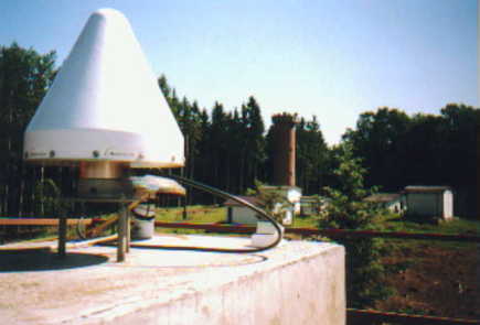
the Trimble 4000SSE receiver with antenna replaced by Ashtech Z18 receiver with Ashtech Choke Ring GG antenna, equipped by protecting radome; observations of GLONASS satellites started, data from both GPS NAVSTAR and GLONASS are sent to the regional data center BKG, Frankfurt Am Main, Germany, together with a meteorological data
24 July 2000 - 4 october 2000
defect of the Ashtech Ashtech Z18 receiver; the reciver as well as its antenna sent to manufacturer; meantime measured by Trimble 4000SSE with Trimble antenna. After repair, a new antenna Ashtech Choke Ring received and employed.
20 June 2001
data for LEO pilot project begin to send to the global data center CDDIS, GSFC, NASA, Maryland, USA (for processing of data from low-earth orbiting satellites).
3 July 2002
the sending of data with GPS NAVSTAR measurements only ended; the data with both GPS NAVSTAR and GLONASS measurements in hourly and daily files is sent since this day (to both data centers - OLG and BKG).
Description of GPS system
Since October 4, 2000 we measure with the Ashtech Z18 receiver, SN 113 and Ashtech Choke Ring Antenna, SN 3301 with protecting radome, IGS description ASH701946.3 SNOW. The following datasets are acquired:
- data from GPS NAVSTAR satellites every 30 seconds in daily files for IGS and EUREF (orbit determination of GPS NAVSTAR satellites, computation of coordinates of the GOPE station)
- data from GPS NAVSTAR satellites every 30 seconds in hourly files to monitor troposhere and for ultra-rapid orbit determination of GPS NAVSTAR satellites - data from GPS NAVSTAR a GLONASS satellites every 30 seconds in daily files to IGS (orbit determination of GLONASS satellites, to estimate differences between the WGS84 and PZ90 systems)
- data form GPS NAVSTAR a GLONASS satellites every 30 seconds in hourly files to IGS (data is sent to the data centers)
- data from GPS NAVSTAR satellites every 5 seconds in 5 minute files for DGPS postprocessing
- data from GPS NAVSTAR a GLONASS satellites every 1 seconds in 15 minute files (for processing of measurements from low-earth orbiting satellites)
Remark: files with measurements from GPS NAVSTAR satellites only are not sent - for the same purpose the files with measurements from both GPS NAVSTAR and GLONASS satellites are used.
S ite information forms from GPS system on GOPE station:
gope_20021014.log (current - IGS and IGLOS)
gope_20020503.log (new format for both IGS and IGLOS)
gope0205.log (IGS) gope0205.lgg (IGLOS)
gope0201.log (IGS) gope0201.lgg (IGLOS)
gope0107.log (IGS) gope0107.lgg (IGLOS)
gope0105.log (IGS) gope0105.lgg (IGLOS)
gope0010.log (IGS) gope0010.lgg (IGLOS)
gope0007.log (IGS)
gope9911.log (IGS) gope9911.lgg (IGEX)
gope9906.log (IGS)
gope9707.log (IGS)
gope9705.log (IGS)
gope9505.log (IGS)
The station is managed by operation center GOP (only in Czech).
Data flow description
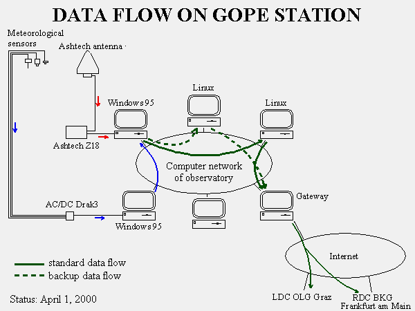
The Ashtech receiver is connected by serial line to a personal computer (on-site computer) to which the measured data are permanently sent. In on-site computer under Windows 95, several programs are running: the primary program is Geodetic Base Station Software (GBSS), prepared by Ashtech; this program stores the measured data on a disk in binary and in RINEX formats, and every hour starts a special program AUTOZ18; this program transforms the data by means of other programs (ASRINEXO, ASRINEXN, ASRINEXG, LINKRNX, RNX2CRX, METRINEX) to the format CompactRINEX, adds the meteorological data from another computer, and prepares the data to transmittion. The data in 5 and 15 minutes files are generated by the program HRLLDATA from the RINEX data files (continuously formed by the program GBSS). Every half on hour, another program is run with the aim to delete data being already transmitted and to organize primary data archive. Also a program to communicate with computer network and to set up accurate time for the local PC is running.

The proper transmittion is realized by operational center GOP (only in Czech). The files with measurements from GPS NAVSTAR satellites are only copied to data archive. The files with mixed measurements from both GPS NAVSTAR and GLONASS satellites are transmitted into both the data center OLG, Graz and the regional data center BKG, Frankfurt Am Main. The data of the 5 minute files is transmitted into an experimental data center for DGPS; the data of the 15 minute files is transmitted into global data center CDDIS.
Providing of unordinary data form permanent GPS observations has own separately page (only in Czech).
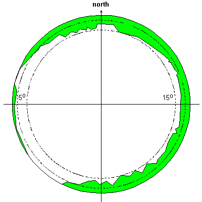
 Sky obstructions